Exail has signed two new contracts for its DriX H-9 autonomous surface drone for maritime defense and hydrographic applications.
Under the first contract, the French company received an award from the innovation arm of an undisclosed navy. It includes equipping the DriX H-9 with counter-drone capabilities supplied by a third-party provider.
The technology will enable DriX H-9 to detect, track, and neutralize hostile aerial unmanned systems.
Originally developed for land platforms, the solution is being adapted for maritime use to extend anti-drone defenses offshore.
Potential applications include fleet protection, escorting high-value vessels, port security, and safeguarding critical maritime infrastructure from aerial threats.
The second contract was awarded by the Hydrographic and Oceanographic Service (SHOM) of the French Navy.
It marks SHOM’s second acquisition of a DriX platform, which will accelerate seabed mapping and data collection for navigation safety and maritime space management.
The two new contracts bring the total number of DriX H-9 orders to three over the past few months.
According to Exail, additional surface drone agreements are currently in final negotiation for 2026.
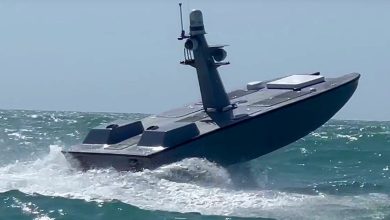
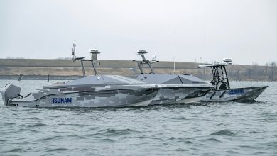
DriX H-9 Solution
The DriX H-9 is a 9-meter (29.5-foot) vessel designed for long-duration maritime missions.
Powered by a diesel engine and carrying 550 liters (145 gallons) of fuel, the DriX H-9 can reach speeds of up to 13 knots (24 kilometers/15 miles per hour).
It can operate for up to 20 days and cover distances of approximately 2,000 nautical miles (3,704 kilometers/2,303 miles).
The vessel can be shipped inside a standard 40-foot (12.2-meter) cube container for transport.
The platform is managed through a human-machine interface designed for mission planning and procedural control.
Its interface provides continuous feedback on vessel status, mission progress, sensor configuration, and system alerts, allowing the operator to modify plans and respond to contingencies during operations.
Featuring a modular payload architecture, the system allows operators to install different sensors and equipment for hydrography, scientific research, subsea inspection, exploration, and infrastructure monitoring.
It also supports towing operations, including the deployment of towed underwater vehicles.
When equipped with multibeam echosounders, the system can conduct seabed mapping at depths reaching approximately 3,000 meters (9,842 feet).